More value from every metre drilled.
GeoZap turns your portable XRF data or multielement geochemistry into automated classification — lithology, regolith, alteration, vectoring to mineralisation. Built and validated by geologists.
- Trained on your project data — your geology, your rules, your needs
- Validated by geologists — geologically meaningful and ready for modelling
- Automated results in minutes — fast turnaround from data to decision
- Remove subjectivity from logging — consistent classification across your entire dataset
- Send us your chemistry data for a specific project
- Receive a PDF report showing preliminary classification results
- Want to go further? Ask for a preliminary study to see what we can do with your data
Free classification — no commitment required.
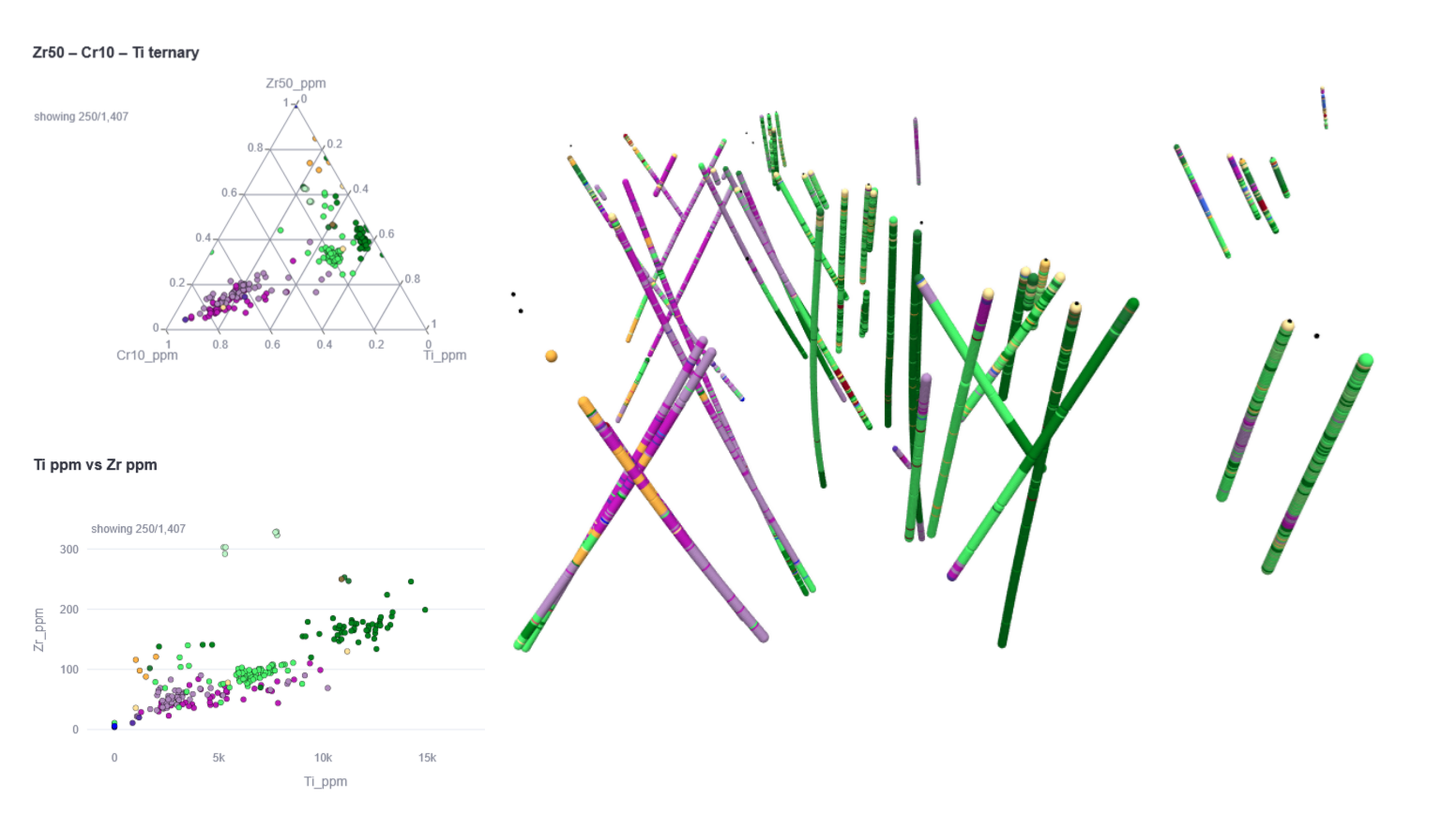
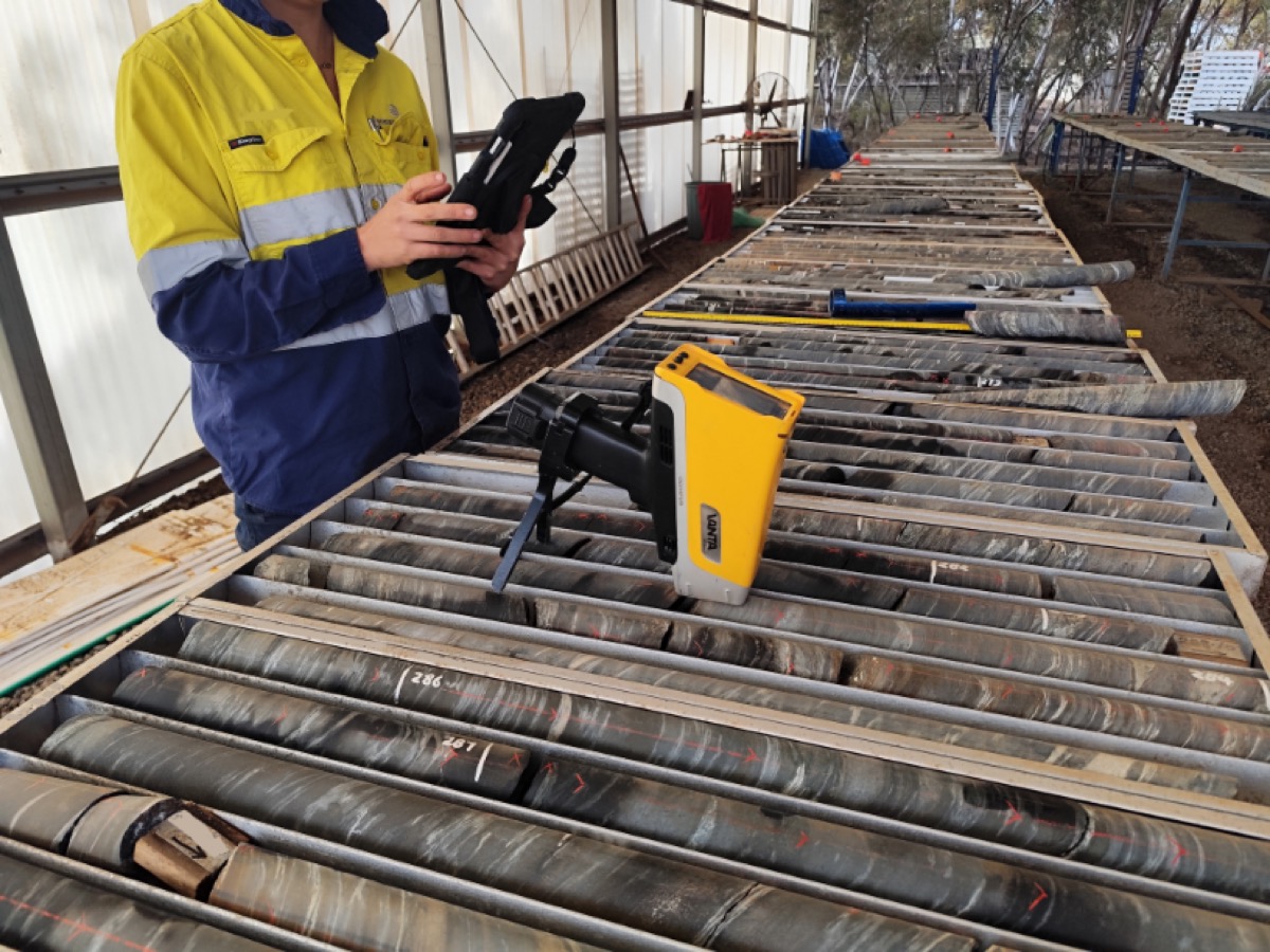
pXRF data is more powerful than most people think.
Many teams collect pXRF data in the field and use it to check a few numbers. We think that is leaving a lot of value on the table. With the right field tools, minimum sample preparation, and a solid QAQC process, pXRF data can discriminate rock types, map alteration, and vector towards mineralisation — automatically, as you collect it.
Fast and easy for operators
Purpose-built for field conditions, minimal preparation required
Powerful classification
Project-specific ML models that extract what generic approaches miss
Make decisions in the field
Shorten a hole, push deeper, prioritise the next target, or redirect resources before it's too late
Faster than lab turnaround
Get interpretation as soon as data is collected, not weeks later
Spend your drilling budget where it counts
Real-time geological insight means fewer wasted holes and smarter programme decisions
Reduce lab costs
Only send samples to the lab for what pXRF cannot answer, or for validation
Two products, one integrated platform
Field Collection & Validation
The entry point to the ZAP ecosystem. Real-time data validation, drift monitoring, and direct database push — on the go, before data drifts too far from the truth.
- Real-time contamination & drift monitoring
- Validation warnings to field operators
- Direct push to your database
- Evident, SciAps, Bruker, Niton
ML Classification — The Core Differentiator
We start by understanding your project — the geology, the objectives, and how pXRF fits into your workflow. We label and validate your data as geologists, then train a model specific to your project. Once set up, every new dataset is classified automatically, on the go.
- Trained on your project data
- Lithology, regolith, alteration, vectoring
- Automated results in minutes
- Dashboard included
Trusted by exploration teams in Australia
We don't replace geologists. We give them more time to think.
GeoZap handles the repetitive work — consistent classification, automated workflows, clean data — so geologists can focus on interpretation, and geochemists can close the gap between data collection and insight.
Consistent, objective classification that removes subjectivity from logging and speeds up geological interpretation.
Automated workflows that reduce the time between data collection and actionable results, without losing scientific rigour.
Not just software. Geological judgement built in.
This is not a software company that built a geology tool. GeoZap are geologists who built software because they lived the problem. When we train a model, we validate it as geologists — looking at the rocks, understanding the project, managing it from the field to the office.
Learn about our approachWorks with FastGeo
Working at the core yard? Collect pXRF data with FastGeo and visualise GeoZap classification results directly on your tablet. Live field data collection meets automated geological interpretation.
Ramelius Resources - Gold explorer
See how Ramelius Resources used the ZAP Platform for automated pXRF lithological classification across their Western Australian operations.
Read Case Study